Abstract
Geospatial modeling provides critical solutions for pressing global challenges such as sustainability and climate change. Existing large language model (LLM)–based algorithm discovery frameworks, such as AlphaEvolve, excel at generic code evolution but lack the domain knowledge required for complex geospatial problems. We introduce GeoEvolve, a multi-agent LLM framework that couples evolutionary search with dynamic geospatial domain knowledge. GeoEvolve operates in nested loops: an inner code evolver generates candidate solutions, while an outer agentic controller—supported by Automated Knowledge Construction and Code-to-Formula agents—queries a Dynamic GeoKnowRAG module to inject theoretical priors. This architecture addresses the challenges of spatial heterogeneity and temporal non-stationarity. We evaluate GeoEvolve on three classical tasks: spatial interpolation (Kriging), uncertainty quantification (GeoCP), and spatial regression (GWR). Across 9 datasets, GeoEvolve discovers novel algorithms that incorporate geospatial theory. It achieves significant gains, such as a 29.5% increase in regression \(R^2\) and a 13–21% reduction in interpolation error. Furthermore, extensive ablation studies confirm GeoEvolve’s robustness across diverse foundation models (GPT, Gemini, Qwen) and its spatiotemporal generalizability, validating that domain-guided retrieval is essential for stable evolution. Collectively, these results offer a scalable path toward trustworthy, automated geospatial modeling, opening new avenues for efficient AI-for-Science discovery.
Method Overview
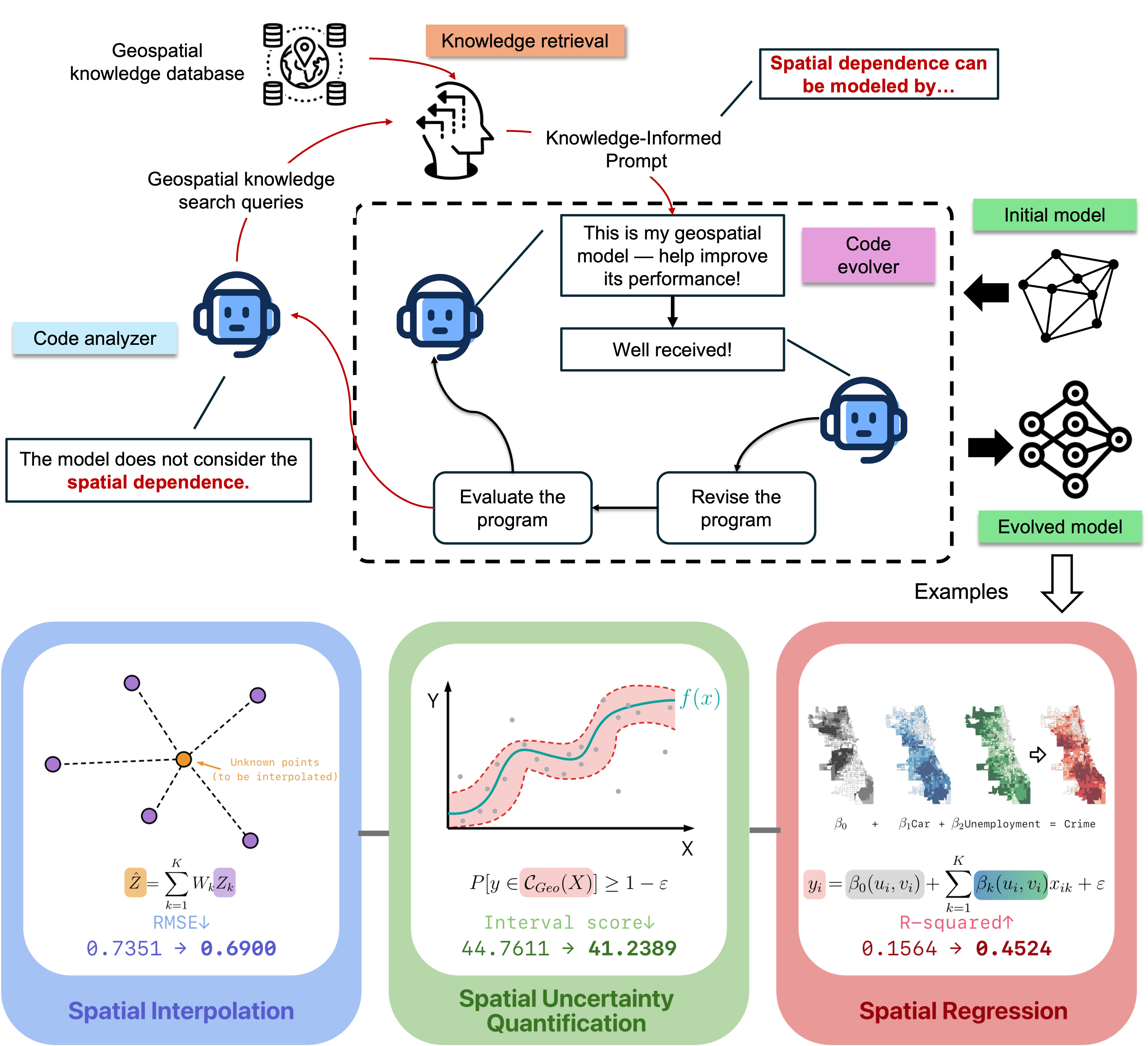
An illustration of the code-evolution trajectory of a geospatial model integrating domain knowledge. The dashed inner box represents the code evolver, a general algorithmic code-generation engine. The surrounding workflow depicts the knowledge-guided code generation proposed in this paper, specifically tailored for geospatial modeling.
Example: Spatial Interpolation Model
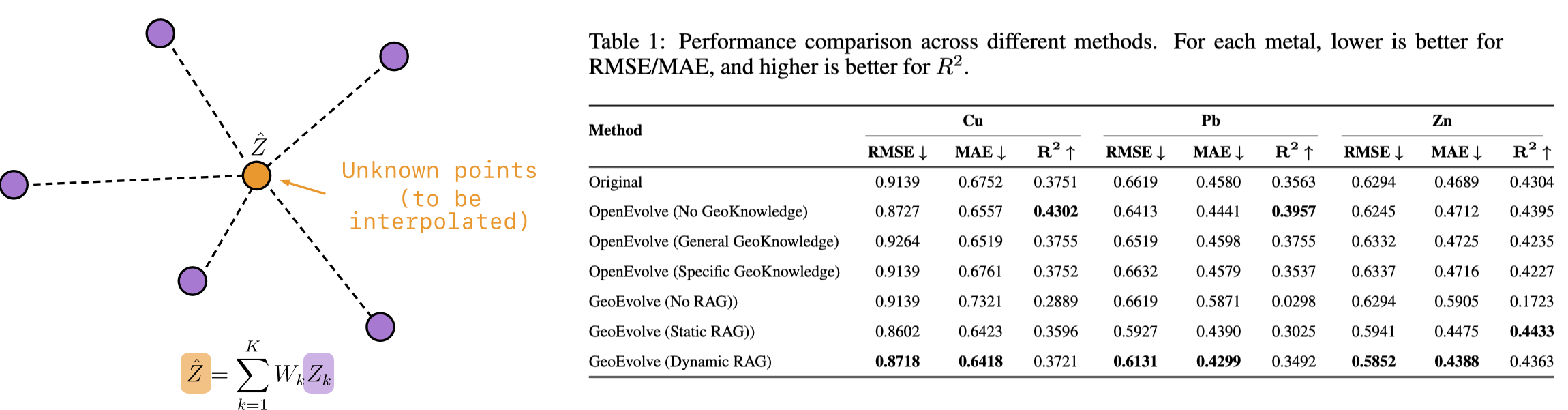
Kriging (Matheron 1963) is a spatial interpolation method used to obtain predictions at unsampled locations based on observed geostatistical data.
Example: Spatial Uncertainty Quantification Model
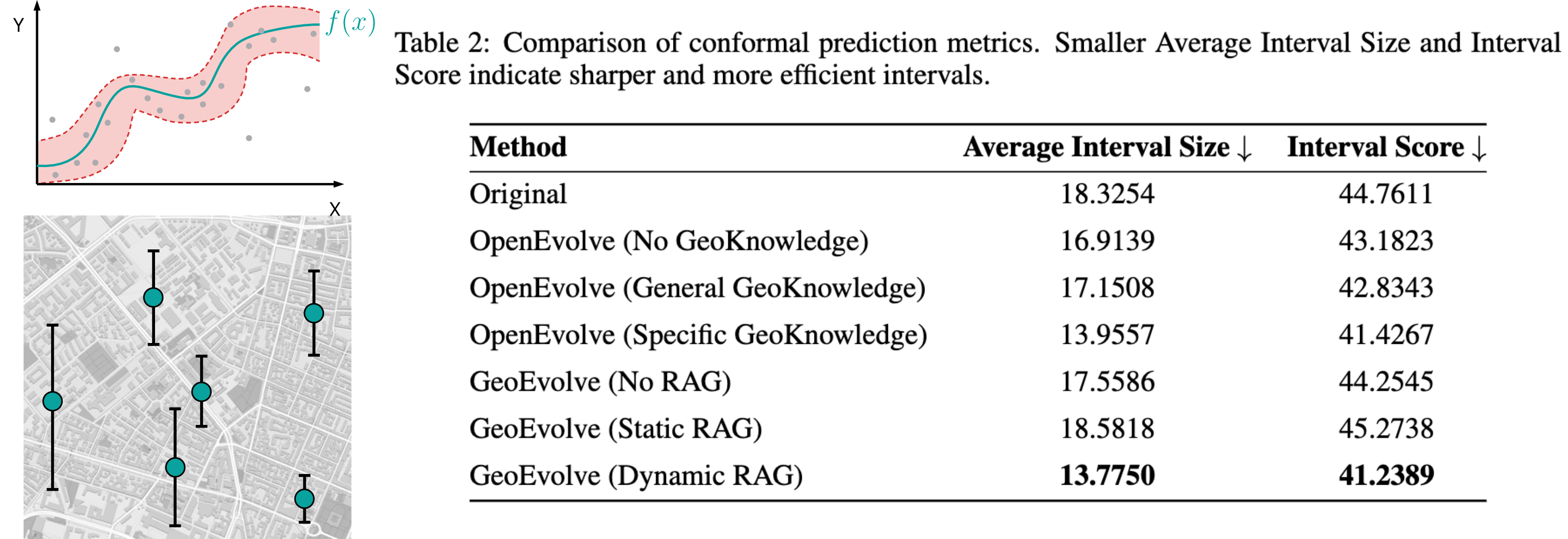
GeoConformal Prediction (GeoCP) is a model-agnostic algorithm for estimating the uncertainty of spatial prediction models (Lou et. al., 2025). $$\mathcal{C}(X)=\left\{y:a(f(X),y)\le Q^{geo}_{1-\varepsilon}(\{a_i\},\{w_i(u,v)\})\right\}$$
Example: Spatial Regression Model
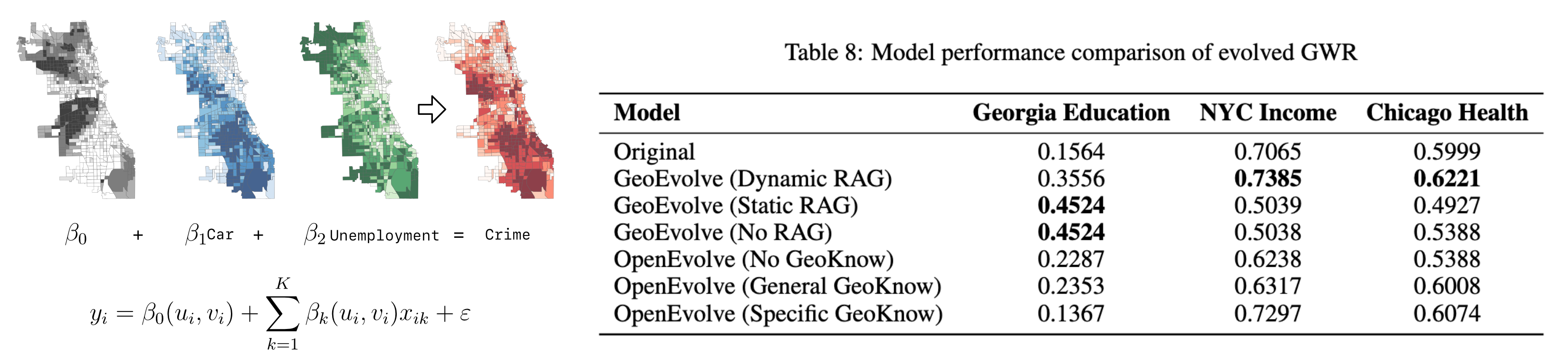
Geographically weighted regression (GWR) (Fotheringham et al., 2009), one of the most famous spatial regression models. For GWR, the regression coefficients are not fixed, but depend on the geographical coordinates of observation。
BibTeX
@article{luo2025geoevolve,
  title={GeoEvolve: Automating Geospatial Model Discovery via Multi-Agent Large Language Models},
  author={Luo, Peng and Lou, Xiayin and Zheng, Yu and Zheng, Zhuo and Ermon, Stefano},
  journal={arXiv preprint arXiv:2509.21593},
  year={2025}
}